A feature of Krabi is the strongly pronounced low tide on the beaches. Probably, here, like nowhere else, it was very much felt. I remember you come to swim, but there is no sea. From the word at all. It has gone far and for a long time, it is impossible to reach it, not that to be bought. Therefore, I had to sort out the tide tables and come at a specific time of the day when the water level is sufficient for swimming. The post serves as a complement to my travel guide to Krabi.
Ebb and flow
Interestingly, although this phenomenon is due to the position of the moon, it does not have a clear period. The most pronounced ebbs and flows are usually around the full moon, and the smallest - during the waning moon. To know exactly when and how much water is leaving, you need to use a special table or program for calculations.
During the maximum low tide, the water on many beaches leaves so far that they become completely incapable, and during the maximum high tide, on the contrary, the water is often practically «eats» a strip of beach and waves beat against the embankment. By the way, during high tide the sea can be rough and muddy. It's good that the tides are on many popular the beaches of Phuket are less pronounced, although very close.
The most comfortable sea on days when the differences between the highest water level and the lowest are minimal. That is, the tide is not very different from the ebb and the water level allows you to swim almost at any time. Usually during the tourist season, this is the very time, and in summer the ebb and flow are more pronounced on many beaches, so swimming in the summer will be more difficult. Rather, find a convenient time for swimming.
You can find the ebb tide table on various sites. For example, on this one. The link leads directly to Krabi. The time will differ depending on the beach, because the height of the water can be different in different locations, but in general it should be similar. The site is in English, but it's easy to figure it out. The site always indicates the time when the highest water height and the lowest.
You can also install an application for Android.
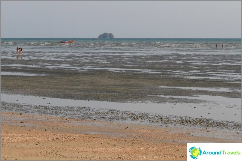
Low tide in Ao Nang (Krabi)
How to use the table
Just in case, I'll tell you how to use the tables from the sites to which I gave links. It's easier to navigate not according to the schedule, but according to tabular data, at least for me. It usually turns out that there are 2 low tides and 2 high tides..
High Tide - maximum water height.
Low Tide - minimum water height.
You need to come closer to the time (plus or minus an hour) when the highest water height, then you can swim normally. There are also night tides that you don't need..
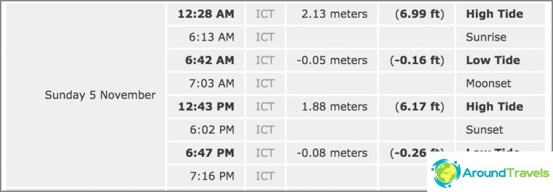
Looking for High Tide in the table
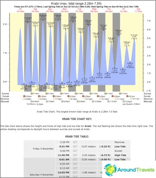
Ebb and flow table in Krabi

