Marshall Islands

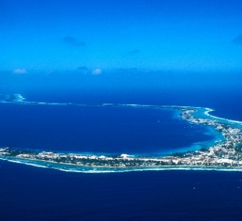
The most interesting countries in the Pacific Ocean include the Republic of the Marshall Islands. It is located in Micronesia and is a group of islands and atolls. The total land area occupied by this state is 181.3 square meters. km. The lagoons cover over 11,673 sq. km. The Marshall Islands are divided into two chains: Ralik and Ratak. They are 250 km apart from each other. The most important islands of the country are Majuro and Kwajalein. The latter is an atoll with the largest lagoon on the planet. Its area is 2174 sq. km. The capital of the state is the city of Majuro.
The Marshall Islands were named for Captain John Marshall. The archipelago is characterized by low-lying relief. The islands have sandy beaches interspersed with coral areas. Most of the archipelago's land is occupied by coconut plantations and mangroves. The Coral Islands are distinguished by infertile soils, so agriculture is not very well developed here..
Weather
The Marshall Islands are located in a tropical climate zone. The weather is hot and humid there. Climatic conditions change from north to south. The northern islands are characterized by a tropical semi-arid climate. The northernmost atoll, Bocake, is almost semi-desert. As you move south, the amount of precipitation on the islands increases. The maximum precipitation falls on the Ebon Atoll, which is the most southerly. The Marshall Islands lie in the area of the northeastern trade winds. Therefore, almost all year round winds blow there from the northeast, which bring moisture with them. Almost all islands are prone to heavy rainfall. Tropical storms and typhoons happen here. Strong winds destroy residential buildings and break trees. At this time, high waves arise in the ocean, threatening the low-lying islands. Droughts in the Marshall Islands also happen.
Features of the natural world
The Marshall Islands are home to tropical plants. Forests have survived only on uninhabited islands. In other places, nature has changed due to human activities. The local flora was almost destroyed, and instead of it people planted plantations of breadfruit, banana and coconut palm. In the middle of the last century, the US authorities carried out nuclear tests on some islands. The first hydrogen bomb exploded in the Bikini Atoll area. Radioactive fallout fell on the neighboring islands, which caused irreparable damage to ecosystems. Currently, the main representatives of the fauna of the islands are seabirds and turtles. There are many fish and corals in the coastal waters. There are no protected areas or reserves in the Marshall Islands.