Kyoto subway: diagram, photo, description

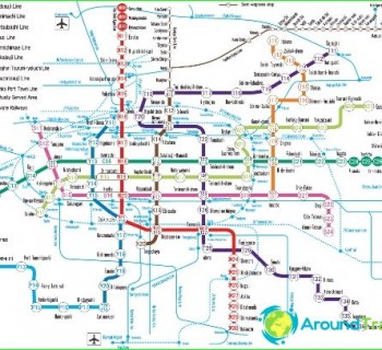
Kyoto subway map
The metro of the former capital of Japan, Kyoto, opened in 1981. It consists of two lines, the total length of which is about 31 kilometers. There are 32 stations on the Kyoto metro routes, which receive at least 130 million passengers per year..
The entrance to the metro station is indicated by a white sign on a bright blue background. It is a triangle-like shape with the top down..
The first line of the Kyoto subway is called Karasuma. It is marked in dark green on maps and connects the northern part of Kyoto with its southern regions. There, the route continues in the form of a railroad, along which trains follow to Nara. The very first section of this part of the metro was opened in 1981, and today the "green" line has already stretched for almost 14 kilometers. There are 15 stations for passengers on the first route of the Kyoto subway. The line runs through Kyoto Main Station.
The second route of the Kyoto subway is marked in red on the map. This line crosses the city from the west through the center to the east, where it makes a 90-degree turn to the south and ends in the Rokujizo area. The "red" route became available to passengers in 1997, and then the line was completed until 2006. It has 17 stations for the entry and exit of passengers. You can change from one Kyoto subway line to another at Kakasumaoike Station.
Kyoto subway opening hours
Photos of Kyoto subway
-

Kyoto subway map
-

-
-