Davis Sea

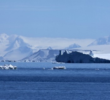
The Davis Sea occupies an extreme position in the water area of the Southern Ocean. Its waters wash over East Antarctica and freely communicate with the Indian Ocean. The reservoir is considered one of the coldest on the planet. It is covered with ice throughout the year, and the water temperature does not rise above zero..
The Davis Sea map shows that it is located next to the Coast of Truth. In those places, the glacier reaches a thickness of 1000 m. This sea is one of the most severe seas in the world. It is smaller in size than the Weddell Sea, but larger than the Amundsen Sea. The reservoir is almost entirely covered with perennial ice. For the first time, people learned about this sea thanks to the Australian Mawson, who got there in 1912 during an expedition. There is a polar station on the Bank of Pravda «Peaceful», built in Soviet times.
a brief description of
The Davis Sea covers an area of about 21 thousand km. sq. The average depth is almost 572 m, and the maximum is just over 1300 m. The salinity of the water is about 33.5 ppm. In the central part of the sea, there is Drygalsky Island, which has an area of about 204 km. sq. The seabed is represented by the Antarctic shelf, turning into the continental slope.
Climatic conditions
The Antarctic Circle passes through the middle of the reservoir. This feature determines the climatic conditions in the water area. The Antarctic climate prevails here. All year round, there is an Antarctic air mass above the sea. The weather is unstable, with frequent winds and snowfalls.
In the Davis Sea, winters are moderately cold. From July to August, the air temperature varies from -28 to -32 degrees. It is almost always cloudy and snowing. In summer, the air warms up very slightly. The temperature drops southward. In the north of the sea, the air temperature is approaching 0 degrees. In winter, the reservoir is completely frozen. Surface waters have a temperature of -1.8 degrees. The upper layers of water are weakly warmed up in summer. The warmest area is the western one, where the water reaches a temperature of about 0.5 degrees. In spring and summer, separate ice-free areas appear on the sea. The Davis Sea has icebergs, drifting ice, fast ice, ice shelves.
The meaning of the Davis Sea
Scientists are working on the seashore studying the features of the icy continent. Antarctic station «Peaceful» conducts work to identify minerals. There is an Australian station in the east of the sea «Davis», whose employees are engaged in the study of the process of global warming. Davis Sea coast is not inhabited.
The organic underwater world is poorly understood due to interference in the form of an eternal ice shell. This sea is home to the Antarctic silverfish belonging to the Notothenium fish.